Trekking Uphill Is Much Easier On Paper Than In Real Life
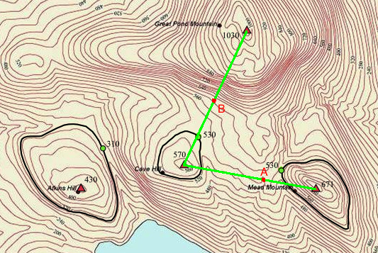 Sarah and Shane plan to hike from Mead Mountain, to checkpoint A, to Cove Hill, to checkpoint B and finally to Great Pond Mountain. They have plotted their course in green in the above topographical map, which shows contour lines at intervals of 20 meters.
Which of the following routes would they experience the steepest ascent ?
Image credit: Wikipedia
This section requires Javascript.
You are seeing this because something didn't load right. We suggest you, (a) try
refreshing the page, (b) enabling javascript if it is disabled on your browser and,
finally, (c)
loading the
non-javascript version of this page
. We're sorry about the hassle.
Geography in Brilliant! ... Brilliant work!...The more the lines closely spaced the steeper it is ... this is the basic concept of contour lines!